- Recent Updates
- Colpoy's Bay
- Colpoy's Bay Introduction
- Spragge's Hill
- The Kalbfleisch House
- The Kalbfleisch Dock
- The Kalbfleisch Marina
- Whicher's Sawmill
- The Wrecks Near Whicher's Mill
- Frame's Falls and John Wood's Grist Mill
- Albemarle Street
- Hughenden and Whicher's Store
- The Community Hall
- The Forest Home Hotel
- The Colpoy's Bay Schoolhouse
- The Colpoy's Bay Church
- Edgehill Cemetery
- Colpoy's Bay From the Air
- A Glimpse of the Past
- Wiarton
- Berford Street
- Berford St. Part 2
- Berford St. Part 3
- Wiarton Harbour
- Bluewater Beach
- Caframo Ltd. and Wiarton Cement Works
- Wiarton Beet Sugar Factory
- Wiarton's Hotels
- Wiarton's Schools
- Wiarton's Banks
- Grand Trunk Railway Station
- The Wiarton Fish House
- The Wiarton Fish Hatchery
- Wiarton's Berford Theatre
- The Wiarton Woolen Mills
- Wiarton's Furniture Industry
- Wiarton's Hospital
- Wiarton's War Memorial
- Wiarton's Town Hall
- Wiarton's Newspapers
- Wiarton's Grist & Flour Mills
- Wiarton's Sawmill Industry
- Wiarton's Gateway
- Connecting Passages
(Links) - Present-day Map
of Colpoy's Bay - Colpoy's Bay
Lot Map (1870) 
Wiarton Timeline- Present-day Map
of Wiarton - Bibliography
- About the Author
- Site Map
(use if menu doesn't work) - Tell me your impressions!
Edgehill Cemetery
The location of the local cemetery in Colpoy's Bay is perhaps one of the most picturesque imaginable. Perched on the brink of a steep ridge at the north end of the village, Edgehill cemetery offers an unrivaled view of Colpoy's Bay and the village that bears its name. (See for instance Figure 8C on "Albemarle Street" page of this website.)
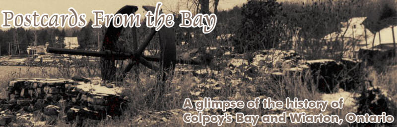
The first recorded burial at the cemetery, dated 1872, was the infant daughter of George and Hannah Bull and granddaughter of William Bull, the first settler in the area surrounding Colpoy's Bay village. (William settled on a large cliffside farm lot south of county road 9 at the top of Spragge's Hill in 1857 shortly before the arrival of John Wood. However, Mr. Bull's property was part of Amabel township, outside of Albemarle township and Colpoy's Bay village.) Figure 14A shows an early view of a sparsely-used Edgehill cemetery. Unfortunately I do not know the date nor the people shown in this image.
Figure
14A: An early view of Edgehill cemetery in Colpoy's Bay. (Date and persons unknown.)
In its early years, the cemetery suffered from insufficient maintenance (like many early cemeteries around the country) as families failed to keep up their plots. The township began keeping someone on the payroll to tend to the grounds (including my great-great grandfather Henry Kalbfleisch who performed these duties from 1899 until 1927). However, more significant action had to be taken around the 1940s as early gravestones (which had been placed on top of the graves rather than beside them) began to tilt or collapse. A cemetery board was established, whose first project was to level the cemetery grounds and reposition tombstones on cement foundations at the head of each gravesite. The current gates at the entrance to the cemetery were erected in 1945, and include prominent names of board members.
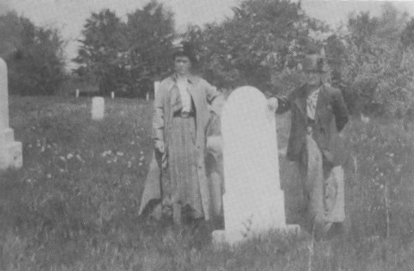
Originally, the cemetery grounds took the shape of a "T". The stem of the "T" was an entrance off of Albemarle St. (Bruce County road 9). This was flanked on each side by private lots. Behind these lots was the burial area, forming the top of the "T". Figure 14B shows the entrance to the cemetery in the late 1940s. On the left is a house built in the early 1890s for John Fraser (blacksmith). This house was purchased in 1897 by my great-grandfather Edwin Kalbfleisch and served as his home until he moved into the former home of Thomas Galbraith along the shore (see the "Kalbflesich House" page of this website). This house was torn down around 1950 to expand Edgehill cemetery (although the actual footprint of the house still remains unoccupied by graves today). The house built to the south of the cemetery entrance (not visible in Figure 14B) was also built in the 1890s for James McDonagh (who built a new home one lot to the south in 1897). For some years, this house served as the church parsonage, but has long since returned to private hands.
Figure
14B: The entrance to Edgehill cemetery before expansion. (Late 1940s.)
Most of the founders of Colpoy's Bay village lie buried in Edgehill cemetery. Notable families such as Wood, Whicher, Kalbfleisch, Carver, Cunningham, Parke, and several others remain etched in stone in the oldest part of the cemetery. Along with them stand other key names from the area outside Colpoy's Bay village such as Alexander McNeill (Bruce County MP from 1882 to 1908 and owner of the Corran estate), and Dr. Hiram Wigle (one of Wiarton's early doctor's; opened a long-running pharmacy in 1890).
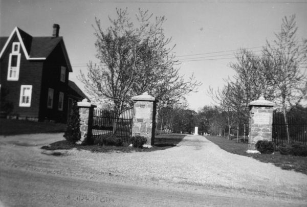
After so many decades of serene peace, December 28, 2008 saw this oldest section of Edgehill cemetery disturbed by a strange coincidence of weather-related issues. A sudden thaw, along with rain the day before, somehow caused a significant section of the cemetery's south side to erode and collapse down the hillside. Figure 14C shows three views of the devestated area.
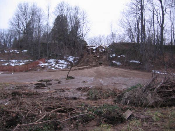
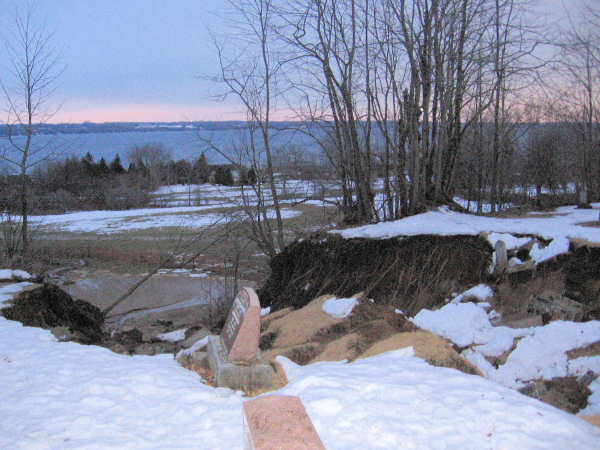
Figure
14C: Damage to Edgehill Cemetery (Dec. 29, 2008).
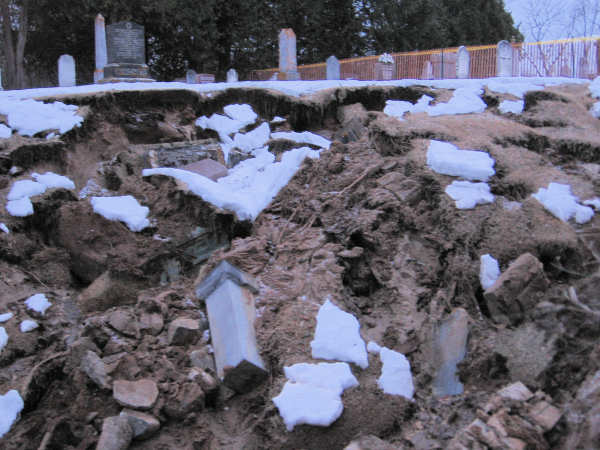
In the months that followed, the Town of South Bruce Peninsula worked to notify affected families (family members were located for about 90% of the affected graves). Archaeologists were also hired to meticulously sift though the soil to collect any human remains. Meanwhile, the affected gravestones were carefully placed out of harm's way, temporarily at the northest corner of the cemetery. Once the archealogical work was complete, the gravestones and remains were re-interred in the northern section of the cemetery. In Octover of 2010, a large stone monument was erected at the sourthern end of the cemetery, near the site of the collapse.
Figure 14D shows the memorial, along with a close-up of listing of graves that were affected by the landslide.
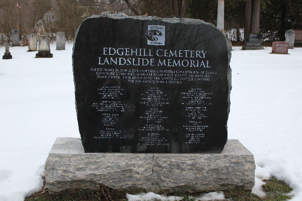
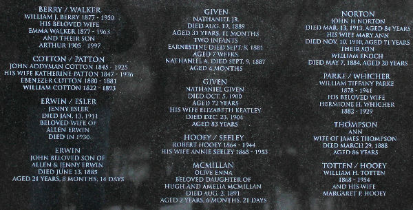
Figure 14D: Memorial to those gravesites affected by the 28 December 2008 landslide. (Jan. 1, 2011).