- Recent Updates
- Colpoy's Bay
- Colpoy's Bay Introduction
- Spragge's Hill
- The Kalbfleisch House
- The Kalbfleisch Dock
- The Kalbfleisch Marina
- Whicher's Sawmill
- The Wrecks Near Whicher's Mill
- Frame's Falls and John Wood's Grist Mill
- Albemarle Street
- Hughenden and Whicher's Store
- The Community Hall
- The Forest Home Hotel
- The Colpoy's Bay Schoolhouse
- The Colpoy's Bay Church
- Edgehill Cemetery
- Colpoy's Bay From the Air
- A Glimpse of the Past
- Wiarton
- Berford Street
- Berford St. Part 2
- Berford St. Part 3
- Wiarton Harbour
- Bluewater Beach
- Caframo Ltd. and Wiarton Cement Works
- Wiarton Beet Sugar Factory
- Wiarton's Hotels
- Wiarton's Schools
- Wiarton's Banks
- Grand Trunk Railway Station
- The Wiarton Fish House
- The Wiarton Fish Hatchery
- Wiarton's Berford Theatre
- The Wiarton Woolen Mills
- Wiarton's Furniture Industry
- Wiarton's Hospital
- Wiarton's War Memorial
- Wiarton's Town Hall
- Wiarton's Newspapers
- Wiarton's Grist & Flour Mills
- Wiarton's Sawmill Industry
- Wiarton's Gateway
- Connecting Passages
(Links) - Present-day Map
of Colpoy's Bay - Colpoy's Bay
Lot Map (1870) 
Wiarton Timeline- Present-day Map
of Wiarton - Bibliography
- About the Author
- Site Map
(use if menu doesn't work) - Tell me your impressions!
Albemarle Street
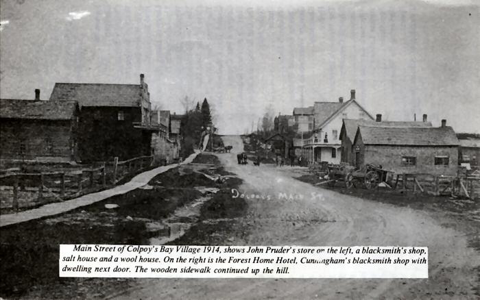


Figure 8A: Albemarle Street looking north. (Top - 1914 from "Days of the Mud Hen", Middle - 2001, Bottom - 2023)
The trip to Colpoy's Bay from Wiarton takes you down Spragge's Hill and along the shore of the bay until you reach the village wharf. At this point, the road makes a 90 degree turn to the north. In 1914 you would round the curve and take in the view displayed at the top of Figure 8A. This image from "Days of the `Mud Hen'" shows the Cunningham home and blacksmith shop at far right (later converted to Cunningham's Hall - see the page of this website entitle "The Community Hall"), the Forest Home Hotel at centre-right, followed by the "drive-in" agricultural weigh scale and homes further up Whicher's Hill, including the former home of Mr. James McDonagh in the distance at right (sold the year before) who was also the architect of the Community Hall (see "The Community Hall"). The structures on the left-hand side are described in the caption within the image.
The bottom two images of Figure 8A show the same view in the summers of 2001 and 2023, respectively. The only buildings that remain on Albemarle St. from 1914 are Whicher's store and a few of the residences, including the McDonagh home (the only one of these remaining buildings visible in either image of Figure 8A).


Figure 8B: Albemarle Street looking south toward the bay. (Top - about 1917 from "Days of the Mud Hen", Middle - 2001, Bottom - 2023)
The top photo in Figure 8B provides a southward view of Albemarle St. from part way up Whicher's Hill, just north of Kribs Road, visible at right. This image dates from around 1917. Whicher's store is at right with the wool and salt houses and Pruder's store further down the street. The weigh scales make an appearance at left. Note the street lamp at far right. It was no doubt powered by Whicher's private generator (as mentioned under "Frames Falls") which was located on Colpoy's Creek, just north of the woolhouse. The same view is given in the bottom two images of Figure 8B as of 2001 and 2023. Once again, only the store remains visible from the former picture.
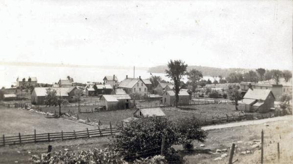 Figure 8C: Colpoy's Bay village looking southwest. 1922
Figure 8C is a great southwesterly view of Albemarle Street and the east end of the village as it stood in 1922. The photograph was taken from the back of Edgehill Cemetery on the eastern side of Whicher's Hill. The Pruder house is the double gabled home at far left. The Parke house is the white brick home to the right with the evident single chimney. In front of the Parke house is Cunningham's Hall (see the page of this website entitled "The Community Hall") The large building at centre, just right of the Parke house, is the former Forest Home Hotel (at the time, the Cunningham home) which was built in 1898 and burned down in 1934. Whicher's store appears at far right behind Alex Caudle's home (one of the residences that remains to this day). It is impossible to take this same photograph today, because of very significant tree growth along the bayside (south) edge of the cemetery. The view is completely blocked.