- Recent Updates
- Colpoy's Bay
- Colpoy's Bay Introduction
- Spragge's Hill
- The Kalbfleisch House
- The Kalbfleisch Dock
- The Kalbfleisch Marina
- Whicher's Sawmill
- The Wrecks Near Whicher's Mill
- Frame's Falls and John Wood's Grist Mill
- Albemarle Street
- Hughenden and Whicher's Store
- The Community Hall
- The Forest Home Hotel
- The Colpoy's Bay Schoolhouse
- The Colpoy's Bay Church
- Edgehill Cemetery
- Colpoy's Bay From the Air
- A Glimpse of the Past
- Wiarton
- Berford Street
- Berford St. Part 2
- Berford St. Part 3
- Wiarton Harbour
- Bluewater Beach
- Caframo Ltd. and Wiarton Cement Works
- Wiarton Beet Sugar Factory
- Wiarton's Hotels
- Wiarton's Schools
- Wiarton's Banks
- Grand Trunk Railway Station
- The Wiarton Fish House
- The Wiarton Fish Hatchery
- Wiarton's Berford Theatre
- The Wiarton Woolen Mills
- Wiarton's Furniture Industry
- Wiarton's Hospital
- Wiarton's War Memorial
- Wiarton's Town Hall
- Wiarton's Newspapers
- Wiarton's Grist & Flour Mills
- Wiarton's Sawmill Industry
- Wiarton's Gateway
- Connecting Passages
(Links) - Present-day Map
of Colpoy's Bay - Colpoy's Bay
Lot Map (1870) 
Wiarton Timeline- Present-day Map
of Wiarton - Bibliography
- About the Author
- Site Map
(use if menu doesn't work) - Tell me your impressions!
Postcards From the Bay
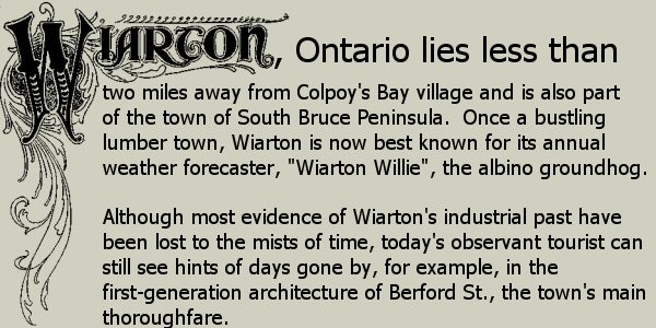
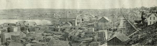
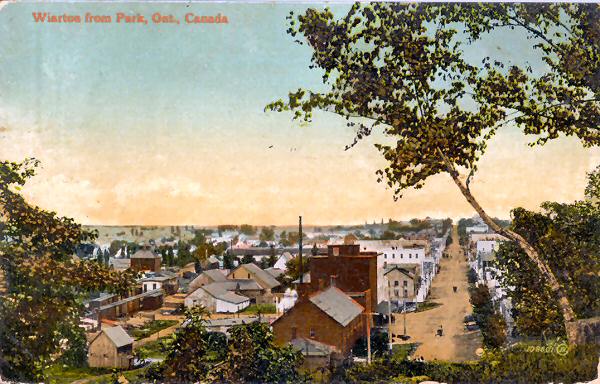
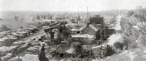
Figure W1A: Berford Street from the north end of Wiarton (1899; c.1905, c.1918)
If you travel south from the village of Colpoy's Bay today, you make a dramatic entrance into Wiarton as Berford Street crests the limestone cliffs formed over 500 to 400 million years ago by coral reefs when the area was covered by a tropical sea.
Wiarton was surveyed in 1855 and settlement began in 1866 (ten years after the settlement of Colpoy's Bay Village). At that time, Berford Street was merely a path through solid bush, stopped dead at its north end by those very limestone cliffs. The original northern entrace to Wiarton was through Gould Street, one block west of Berford Street, thereby avoiding the cliffs. As such, Gould Street marked Wiarton's original business district. However, as the lumber industry and harbour gained in importance, one by one the major businesses relocated to Berford Street. By the arrival of the railway in 1882, Gould Street had become largely a residential district, which it remains today.
Figure W1A gives three amazing early views of Berford Street looking south from the edge of the limestone cliffs (where the north hill road currently lies). Many of Wiarton's key structures are visible in these views and you can read more about them in the other pages of this website. The top image in Figure W1A, which dates from 1899, gives a great impression of the dominance of the lumber trade in the town's early days. The shoreline at left is dotted with sawmills and the sheer volume of their output is visible at the bottom left of the image. In these days, Wiarton was often referred to as "Sawdust Town".
The middle image in Figure W1A is a postcard image taken about six years later. The rapid development of Wiarton is noticable between these two photos. By the early 20th century, the large brick grist mill facilities had been built on the left at the bottom of the image (today, this building serves as residential units - for more info, see the "Wiarton's Grist and Flour Mills" page on this website), behind which you can see Ely's (aka the Commercial) Hotel. The Arlington Hotel is visible as the taller white building with a visible row of windows, further down Berford Street. The original train station (c. 1882) is also within sight at the bottom left next to the tree branches. More information on most of these buildings is available elsewhere on this website. As you can see from the caption on this postcard, the top of the limestone cliffs served as a park at that time.
The bottom image of Figure W1A shows a similar view likely from the late 1910s. This picture distictly shows how Berford Street once turned diagonally toward the shoreline at its north end where it met the limestone cliffs. Cutting through the area that now lies between the former grist mill and the home long-known as the "Anchor Inn", Berford St. effectively merged into what is now known as Bayview (aka Bay) Street.
Of course, in Wiarton's early days, the streets were still the domain of the horse and carriage. However, the arrival of Wiarton's first car in 1904 marked the beginning of a growth in traffic that continues to this day. This fact, in combination with the central importance of Berford Street, led to the decision to cut through the limestone cliffs to provide a direct path north out of Wiarton.
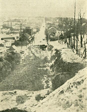
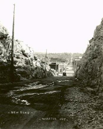
Figure W1B: Cutting through the rock at the north end of Berford Street (c.1928; c.1929)
The top image of Figure W1B gives a fantastic view of the 1927/1928 Berford Street "rock cut" in progress. The finished product is shown in the bottom image. It appears the blasting, likely done with dynamite, gave a significantly less clean cut than what one sees today, however, it did the job. In 1928, Wiartonians had their first chance to enter town through walls of limestone, the same way one does today.
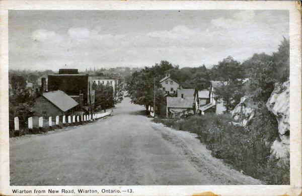
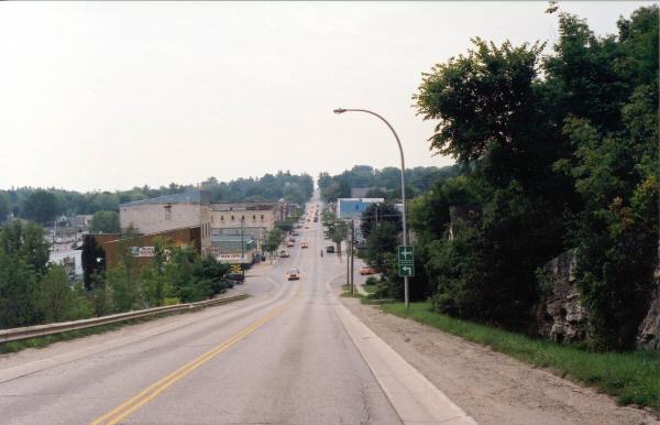
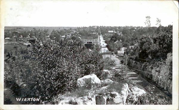
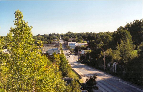

Figure W1C: Berford Street looking south from the rock cut. (c. 1950; 2001; 1949, 2001, 2023)
Figure W1C gives four views of Berford Street from the rock cut. Note in the top image of Figure W1C, taken about 1950, how the bottom of the hill had been raised to make a more gradual slope. The buildings north of the old grist mill, at left, were no longer even with road level, thus cutting off access to the original path of Berford Street over to Bayview St. In more recent year, tree growth has obscured much of the view from this location, as seen in the bottom image from 2023.
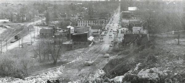
Figure W1D: Widening the rock cut at the north end of Berford Street (1968)
From much the same perspective as Figure W1A, Figure W1D shows further widening and deepening of the north hill rock cut in 1968-9.
Interestingly, the old Gould Street "bypass" once used to get around the cliffs at the north
end of Berford Street (in the days before the rock cut), remained accessible until the 1960s when additional blasting deepened the cut and made the road less steep. Today, one
can still drive down Gould Street to get to the old bypass, but its stop sign truly marks its end...with a 10-15 foot drop!
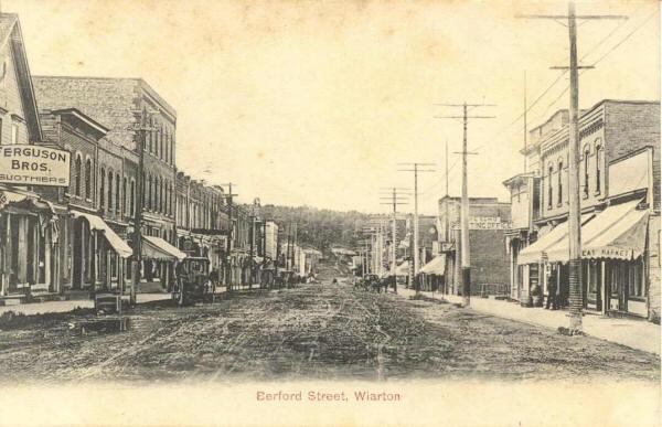
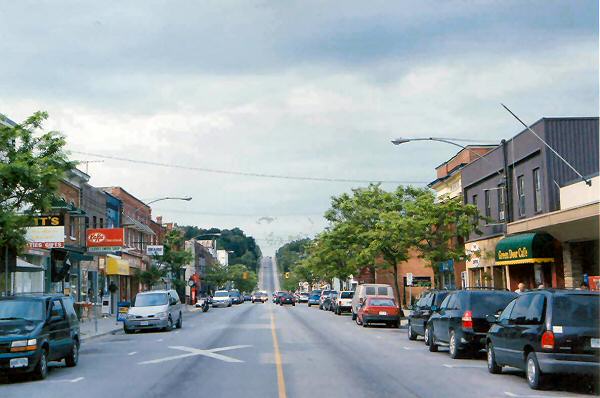
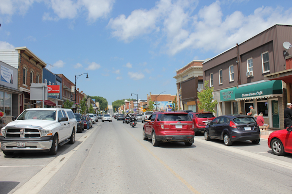
Figure W1E: Berford Street looking north toward limestone cliffs. (c.1905; 2004, 2022)
I include Figure W1E to give you a perspective of the rock cut looking north down Berford Street. In the top image, which dates from about 1905, one can clearly see how Berford Street does not continue up the limestone cliffs.
Instead, the cliffs are densly forested, hiding much of the limestone from view. By comparison, in the middle and bottom images (from 2004 and 2022, respectively), Berford St. continues north through the rock cut and up the Bruce Peninsula (as Highway 6).